With the rapid development of land and resources management information technology and the application of cadastral survey, land use change survey monitoring and verification, land law enforcement inspection, geological disaster monitoring, scientific research base series technology research, land and resources management for information data collection And the updated technical requirements have been further improved. Compared with traditional data acquisition and update mode, UAV aerial system has a low cost, high efficiency, fast timely access to the advantages of large-scale high-resolution image can be used as an effective complement to traditional data acquisition and more new ways to meet The need for the development of information technology.

Chinese name: UAV land and resources management
Foreign name: uav land and resources management
table of Contents
background
Industry demand
UAV system features and advantages
UAV applied to land and resources system
Specific application direction
background
National land resource information is an important basis for formulating national economic development plans and macro-decisions, and is also a need for sustainable development of the country. The UAV flight platform has played its own advantages in the field of land and resources survey. Low-cost, low-speed, long-distance, high-reliability drones perform low-altitude missions, and operators can easily control the flight of aircraft on the ground. Route and flight height.
The use of drone technology to carry out land and resources surveys and land use monitoring can reflect the specific conditions of various land and resources in a timely manner, enhance the foresight of resource development, environmental protection and disaster prevention, for land development and remediation, environmental and disaster monitoring, Provide basis for hydrogeology, engineering geological exploration, site selection, line selection and urban planning of construction projects.

Industry demand
1. China's vast territory, land and resources management has certain limitations on the control surface, through the existing manual methods, the efficiency is not high;
2. In the urban planning survey, the satellite imagery is not high-definition, and it is impossible to obtain an effective high-altitude visual aerial view, and the planning basis is insufficient;
UAV system features and advantages
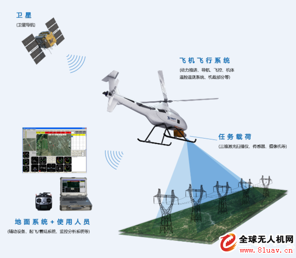
An unmanned aerial vehicle is an unmanned aerial vehicle controlled by radio remote control equipment and a self-contained program. The drone system mainly includes flight platform, data acquisition system, ground monitoring system and supporting operation software.
UAV digital photogrammetry technology is a remote sensing application technology that comprehensively utilizes advanced unmanned aerial vehicle technology, remote sensing sensor technology, remote control program control technology, communication technology and GPS differential positioning technology. It has automation, intelligence and specialization to quickly acquire land. Space remote sensing information such as resources and environment, and the application technology of remote sensing data processing, modeling and application analysis is a new type of aerial remote sensing technology developed after satellite remote sensing and general aerial photogrammetry technology. The technology has the following unique features. Advantage.
1. Low cost of use and easy operation
The system has a high degree of automation, simple operation training, and can work at any time according to the needs of the task. The take-off and landing of drones adopts the method of ejection take-off and parachute landing, and the flying height can reach more than 4000m, which can fully adapt to the application of various topography and landforms in Hunan Province. UAVs can be photographed at low altitudes, and with their fast maneuverability, the weather for aerial photography is much more than for ordinary aerial photography.
2. Maneuvering fast response
After receiving the aerial camera mission, the technical system can achieve rapid dispatch, fast acquisition, fast processing, rapid analysis and discrimination, and has the characteristics of short drawing period and strong timeliness.
3. High-resolution aerial image acquisition capability
The system can obtain high-resolution images better than 8 cm. The images are rich, clear, intuitive and accurate. They can meet large-scale mapping, land classification, land information extraction, etc., and can be used as important decision-making basis.
4. Fast processing ability of aerial photography
The system uses digital remote sensing equipment, and the acquired high-resolution images can be directly transmitted to the computer for processing. DEM, orthophoto maps, topographic maps and other data required for land development and consolidation are quickly generated by dedicated automatic three-way automatic correction, automatic splicing, and vector mapping software.
UAV applied to land and resources system
1. Prior control: urban planning survey ( railway construction; land use status update, monitoring and inspection, land change survey; land type division; land law enforcement ) , mineral resources development survey, coal fire survey and other land resource surveys.
2. Post-evaluation and inspection: assessment of agricultural land resources and crop resources, archaeological surveys.
Specific application direction
First , prior control
1. Town Planning Survey
UAVs carry digital cameras flying over the city, providing a basis for planning information systems developed by the city. Widely used research on building density distribution law, construction site survey, central city shed survey, construction road occupation, open parking lot survey, space distribution of garbage dump, supplementary treatment of sewage treatment and renovation project, construction of factory Planning or retrofitting to provide image data, etc. In addition, it can also be applied in railway construction, urban changes, development trends and renovations, urban maps, and urban status surveys, such as land use status updates, monitoring and inspections, land change surveys, land types. Divide, land law enforcement cadastre, transportation, tourism resources survey, draw urban green distribution map, smoke pollution distribution map, water pollution distribution map, and urban environmental survey, such as three waste pollution, geological disasters, urban public safety monitoring.
2. Mineral resources development survey
The exploitation of mining areas in China has caused the destruction of the ecological environment. The implementation of mineral resources planning is unclear, and there is no objective and effective data. Due to the lack of real-time monitoring, illegal activities occur frequently. Location of mining sites (wellhead location), mining status (mining or closing), mining (coal, iron, etc.), mining methods (open air), land occupation and land type, solid waste in UAV aerial remote sensing mining area Stacking range and type of land occupied. UAVs can also observe disasters caused by the exploitation of mineral resources. Including the ground subsidence range, the length of the ground fissure, the location of the collapse pit, the range of the mountain collapse (collapse), the location of the collapse, the location of the landslide, the location of the debris flow, the length of the channel (position) and the spontaneous combustion range of the coal field (coal gangue). The detection of mine ecological environment information includes the destruction of land scope, damaged vegetation range, dust pollution range, water pollution range, desertification range, land reclamation range and mine environmental treatment effects. UAV low-altitude remote sensing combined with ground management software can also provide decision-making support for the overall status of mineral resources development.
3. Survey of land resources such as coal fire investigation
Coal seam spontaneous combustion is one of the common disasters in coalfields in northern China, which has lost a lot of coal resources. According to available data, many coal fields have spontaneous combustion of coal seams. The country loses about 200 million tons of coal per year, accounting for 20% of the total annual national mining volume, while releasing a large amount of harmful gases. Such as: C02, H2S, CO, etc., seriously polluting the atmospheric environment, causing the ground to collapse, threatening the safe production of the mine. The purpose of the UAV coal fire investigation is to provide coal seam combustion data and data for specific mining areas, and to provide specific fire fighting plans, estimate fire fighting costs, predict combustion trends, and check fire extinguishing effects.
4. Geological disaster monitoring
In order to further carry out the monitoring of geological disasters in key areas of Hubei Province and change the status of its occurrence, wide distribution, high frequency and heavy disaster situation, the UAV remote sensing monitoring system can carry out aerial photography of drones to obtain higher resolution. The image provides a clear source of image data for regional disaster prevention and dynamic remote sensing monitoring, providing accurate information to the government and regulatory authorities. In addition, when the danger occurs, the drone can also overcome the unfavorable factors such as traffic disruption, quickly rush to the danger zone, use the aerial camera system to obtain the latest dangerous images, and monitor the development of the danger.
5. Land law enforcement inspection
The land law enforcement inspection is characterized by tight time and urgent tasks. The use of the latest high-resolution remote sensing data is the basis for its work. Although these areas are generally not large in size, satellite remote sensing is often unable to obtain the required remote sensing data in time due to factors such as its return cycle and weather. The rapid response and high-resolution data acquisition capabilities of the UAV system have significant advantages over other remote sensing methods.
Second , after-the-fact evaluation and investigation
1. Assessment of agricultural land resources and crop resources
UAV remote sensing can quickly estimate crop acreage, crop growth monitoring and yield forecasting, crop drought and irrigation monitoring and use for agricultural natural resource management. Interpret and judge problems encountered in agricultural production, such as pests and diseases, soil salinity, soil nutrient status, water pollution and other issues. Agro-ecological environment change monitoring: grassland degradation, land desertification, soil erosion water environmental pollution monitoring and agricultural water environment resource supply planning.
2. Archaeological investigation
UAVs interpret certain features of ground or underground sites by observing and photographing them from different angles and at different times, using various features such as landforms, ground shadows, floods, frost, snow, soil moisture and vegetation. Under favorable conditions, information on certain underground sites can also be manifested by interference with ground information. Due to the expansion of the field of aerial remote sensing surveys, it is easy to identify some of the sites and relics that appear disorganized on the ground through faintly revealed “interpretation marksâ€. Especially in areas with inconvenient transportation, difficult access to people, harsh natural conditions and complex landscapes (such as certain mountains, deserts, plateaus, and water networks), archaeological surveys using remote sensing image interpretation methods are the fastest methods. This method is very common in foreign countries and is very successful. For example, in Germany, an aerial remote sensing archaeological survey in Bavaria has increased the number of ancient sites by more than one third. In the late 1980s, China used a satellite film to accurately circle a section of the “Golden Great Wall†(also known as the Genghis Khan side wall or the Phnom Penh Fortress) that was nearly a thousand kilometers long and covered with snow. On the image, the moat of the Bianbao, the Mouth Gate and the ancient city of the garrison along the border are all unobstructed. Their images are clear and unforgettable. These are unmatched by the field archaeological survey.
3. Cadastral survey
Cadastral survey is an important foundation for land management. Based on cadastral surveys, it uses measurement techniques as a means to accurately measure the location and size of various types of land, the boundaries of boundaries and boundaries of land and land, and the cadastral maps to meet the land. The needs of management and other national economic construction departments. The traditional method of data collection in the whole field is mapped, the workload is large, and the cost is high (the cost per km 2 is 8~150,000 yuan), and it is not suitable for large-scale development. Compared with field measurements, UAV aerial survey has the characteristics of short cycle, high efficiency and low cost. For large-scale large-scale topographic survey tasks (10~100 km 2), it is less restricted by weather and airspace management. low. The engineering and practical development of the UAV remote sensing system can take advantage of its maneuverability, speed and economy. It can also obtain qualified color images on cloudy and light fog days, thus transferring a large amount of field work. The internal work can not only reduce the labor intensity, but also improve the technical level and precision of the work.
4. National Land Use Change Survey Monitoring and Verification
The annual demand for remote sensing data in the National Land Change Survey, Monitoring and Verification Project is very large and time-sensitive. Satellite remote sensing data is often difficult to meet demand, especially in some key regions, such as 35 countries that approve and supervise cities. These areas are generally small in size and require high-resolution remote sensing data for monitoring within one to two months of the end of the year. Due to factors such as capacity and weather, it is difficult for high-resolution remote sensing satellites to obtain all remote sensing data in such a short period of time. UAV aerial photography system is used in conjunction with high-scoring satellites. For areas where high-scoring satellites do not have qualified data, the UAV system is activated at a certain time, which can greatly increase the probability of full coverage of high-scoring remote sensing data in these areas. Guaranteed change investigation and monitoring are available on the basis of evidence.
In addition, in some mountainous areas with complex terrain, the reception of satellite remote sensing data is very difficult due to poor weather conditions. In some areas, it is often difficult to carry out work due to the failure to receive qualified remote sensing data before the change survey. In the current situation that radar satellite data is still unable to meet the requirements, if the funds are guaranteed, the use of drone aerial photography may be the only technical means to obtain remote sensing data in these areas in time.
10 Mm Nano Tip,Smart Board Touch Screen Pen,Electronic White Board Pen,Infrared Touch Screen Pen
Shenzhen Ruidian Technology CO., Ltd , https://www.wisonen.com